LOCATIONS
J - M
A – B C – E F – I J – M N – Q R – T U - Z
|
PLACENAME |
WHERE |
HISTORY |
|
Jack’s Bay |
Small bay about a mile sth of Catlins River estuary. Hayward Point is northern headland |
Name refers to John Tuhawaiki |
|
Jack’s Island |
Off southern end of Jack’s Bay |
|
|
Jackman’s Stream |
Small creek flowing into Glenomaru Stream |
Named after JACKMAN, early settler and sawmill owner |
|
Jacob’s Hill |
Prominent hill overlooking Newhaven |
Named after an old maori |
|
Johnstone |
5km from Waitahuna |
Named after surveyor of district |
|
Kahuika |
District between Caberfeidh and Maclennan, 24km from Owaka |
Said to mean ‘meeting of the waters’ |
|
Kaihiku |
Old railway siding in district between Warepa and Waiwera, 19km from Balclutha |
‘Kai’ is food, ‘hiku’ tail of fish. |
|
Kaihiku Range |
Prominent range running from Warepa to Clinton |
|
|
Kaihiku River |
Rise southern slopes of Kaihiku Range |
Flows into Clutha River 6mls upstream from Balclutha |
|
Kaimaitaitai |
Name for old port at The Nuggets, 30km from Balclutha |
‘Kai’ food, ‘mataitai ‘salty’ |
|
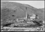
Kaitangata
Kaitangata Coal Mine c1890 |
Coal mining centre in South Otago situated on Matau branch of Clutha River, 13km from Balclutha |
One meaning given -‘Kai’ to eat, food; ‘tangata’ man’. Battle fought here between two tribes over eeling rights, chief Mokomoko being killed and eaten by victors. Another is that was named for Kaitakata of Arai-te-uru canoe who found type of clay used in painted designs. Another version is based on mythology, Rupe’s son, Kaitangata was crushed by a heavy beam and his blood spread across the heavens, explaining sky at sunset. |
|
Kaiwera |
Stream flowing around south side of Otaraia Hill into Waipahi River. |
Corruption of ‘Kahuwera’, hot clothes. ‘Kaiwera’ would be hot food |
|
Kaka Point |
Seaside town between Port Molyneux and Karoro Creek, 22km from Balclutha |
Name refers to native parrot once common in district |
|
Kakapuaka |
Old railway station and township 3mls west of Balclutha |
Railway station was originally Waitepeka and post office Kakapuaka. Settlers petitioned to change railway station to Kakapuaka |
|
Karoro Creek |
Small creek flowing into Willsher Bay |
Maori name for black backed gull OR short for Ka-o-Ue, fire of Ue |
|
Katea |
District 5km up Hunts Road, 5km from Owaka |
Probably abbreviation of ‘kahikatea’ the white pine |
|
Kenneth Peak |
Mountain 1mile nth of Tahakopa River |
|
|
Koau River |
Commencing just below railway bridge at Balclutha, the Koau River is the branch of the Clutha River forming western boundary of Inch Clutha and southern boundary of Balclutha |
Koau is Maori name for pied shag. |
|
Kuramea |
Maori name for Catlins River |
|
|
Kuriwao |
District 48km from Gore 5km sth of Clinton. Also Kuriwao Peak - prominent peak within area |
Maori name was ‘Koaka-kaeaea’ – nest of the sparrow hawk |
|
Kuriwao Stream |
Rises in hills south of Clinton, flows down Kuriwao Gorge, west of Kuriwao Peak then through Clinton district into Waiwera River |
Kuri means dog and wao is forest |
|
Lawrence |
96km from Dunedin on Central Otago Highway |
Named in 1857 after Sir HM LAWRENCE, hero of Indian Mutiny |
|
Lochindorb |
Also known as Shaw’s old run. Top end of Puerua Valley |
Lochindorb is a lake in Morayshire, Scotland |
|
Long Point |
Prominent headland 7 miles east of Tautuku Peninsula. |
S.S. Manuka was wrecked here in 1929. Maori name was ‘Irihuka’ – hanging with foam |
|
Longbeach Creek |
East of Waikawa Harbour. |
Boundary between Otago and Southland |
|
Lovell’s Flat |
District between Moneymore and Stirling, 14km from Balclutha. Also Lovells Creek |
Originally owned by pioneer settler, John LOVELL, one of whose sons discovered coal at Kaitangata. |
|
MacKenzie Stream |
Rises near Tarara and flows into Catlins Lake near Ratanui |
Named after Sir Thomas MACKENZIE, MP for district |
|
Maclennan |
Old railway station on Catlins River line where Maclennan River joins the Tahakopa, 63km from Balclutha |
Murdoch MacLENNAN took up the MacLennan run in 1884 |
|
Maclennan Range |
Range between head waters of Tauruku and Tahakopa Rivers. |
|
|
Maclennan River |
Small river rising near Ajax Hill, about 5 miles nth of Tahakopa Valley, flows into Tahakopa River |
Maori name ‘Waimaeroero’ |
|
Manuka Creek |
District just beyond the Manuka Gorge on Lawrence/Central Otago highway, 14km from Milton |
Manuka shrub growing prolifically in area |
|
Manuka Island |
Small island in Clutha River , 3 miles up from Balclutha |
|
|
Maranuku |
Maori reserve at Karoro |
|
|
Marshall’s Creek |
Also known as Awakia Stream |
Matthew MARSHALL was a shepherd of Meredith’s Popotunoa Run in 1853 |
|
Mataipipi |
Old time Maori pa at mouth of Clutha River near Coal Point |
|
|
McPhee Cove |
Small bay west of Pillan’s Head |
Named after McPHEE, boat builder at Owaka River |
|
Measley Beach |
Between Clutha and Tokomairiro |
Large party of Maoris died from measles c 1835 |
|
Milburn |
Small settlement 6km north of Milton |
Name derived from ‘Millbourne’, property name of Mr BLACK, so named because of stream flowing through farm the water from which drove the wheels of mills at Milton |
|
Miller’s Point |
Catlins |
|
|
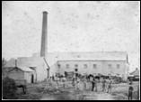
Milton
McGill’s Flour Mill, Milton est 1858 |
Town at heart of Tokomairiro region |
Name derived from Mill Town, the settlement around McGill’s flourmill and several other mills in the area |
|
Mokamoka |
Name adopted for short period for Pounawea |
|
|
Molyneux |
Alternative name for Clutha River |
Captain Cook named what he took to be a harbour after Robert MOLINEUX, sailing master of ‘Endeavour’ who died during the voyage. Whalers adopted name for the river. Old miners referred to the river above Cromwell as the Clutha and below, the Molyneux. |
|
Moneymore |
District 6km south of Milton |
Named after district in Ireland where guardian of orphaned MARTIN family came from. Property named Moneymore Farm. Formerly known as Southbridge or South Toko, name changed as confusion with same name in Southland. |
|
Mount Cooee |
Hill on bank of Clutha to north of Balclutha |
So named as settlers often had to ccoey loudly to attract attention of ferryman. |
|
Mount Roseberry |
Highest peak in South Otago called the Steep Face area, about 15 miles south of Clinton and 20 miles north of Chaslands. |
Three early runs, the Merrie Creek, the Cairn and the Wisp shared the rough tussock country of this area. |
|
Murikauhaka |
Old Maori village at old mouth of Clutha River (near Port Molyneux) |
Canoes were tied up in a backwater. ‘Muri’ means behind, ‘kauhaka’ a bay |
A – B C – E F – I J – M N – Q R – T U - Z
|
Sources: |
‘Pioneering in South Otago’ by F Waite, pub. 1948 ‘Catlins Pioneering’ by AR Tyrell, pub. 1989 ‘Faith and Toil’ by DJ Sumpter and JJ Lewis, pub 1949 ‘Full Circle’ 1975 ‘Place Names of New Zealand’ by AW Reed, pub 1975 ‘Otago Place Names’ by JH Beattie, pub |
Please let us know of any we have missed, or are incorrect
Contact: Webmissus at help.desk@balcluthagenealogy.org.nz
‘Locations J - M’ last updated 6 July 2012
© Balclutha Branch NZSG (Balclutha Genealogical Society)